Tropical storm possible this weekend
Published 1:44 pm Friday, June 18, 2021
|
Getting your Trinity Audio player ready...
|
The first major rainfall event of the 2021 hurricane season was expected to hit Washington Parish this weekend, as local officials kept their eye Friday on what was then being called “Potential Tropical Cyclone Three.”
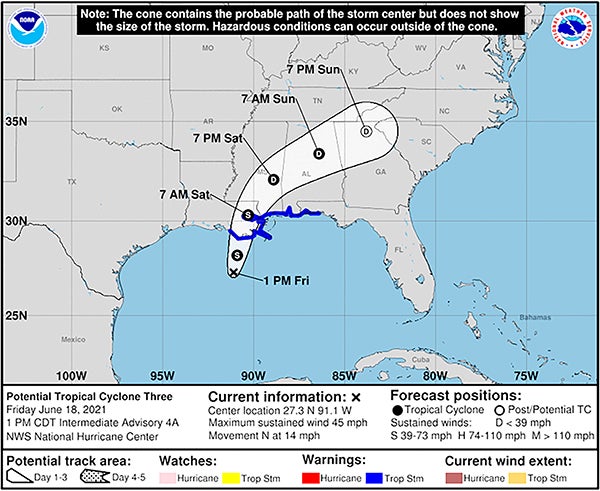
In its 1 p.m. Friday update, the National Weather Service in New Orleans said that the storm was about 250 miles south-southwest of New Orleans, with intensity of 35 mph and moving north-northeast at 14 mph.
It was expected to become a tropical depression or tropical storm later Friday. Upon development into a tropical storm, its name would be changed to “Tropical Storm Claudette.”
The NWS said that rain bands were already moving on shore and winds were increasing over coastal waters, with numerous oil platforms seeing wind gusts up to 40 mph Friday morning.
Although there was no official Tropical Storm Warning for Washington Parish in that 1 p.m. update, there were warnings issued for parts of St. Tammany and Tangipahoa parishes.
The most pressing dangers from the storm system are potential for flooding rains and occasional tornadoes.
Louisiana Gov. John Bel Edwards issued a state of emergency on Thursday, in anticipation of the storm. In addition, several municipalities in Washington Parish offered citizens the chance to fill sandbags throughout the day Thursday and Friday.
The NWS’s weekend forecast for Bogalusa included the following:
- Saturday during the day — Showers and possibly a thunderstorm before 4 p.m., then showers and thunderstorms after 4 p.m. Some of the storms could produce heavy rain. High near 84, with a chance of precipitation at 90 percent. New rainfall amounts between three-quarters and one inch possible.
- Saturday evening — Showers and thunderstorms before 10 p.m., then showers likely and possibly a thunderstorm between 10 p.m. and 1 a.m. Sunday, then a chance of thunderstorms after 1 a.m. Some of the storms could produce heavy rain. Low around 73, with a southwest wind 5 to 10 mph and 80-percent chance of precipitation.
- Sunday during the day — Showers likely and possibly a thunderstorm before 1 p.m., then showers and thunderstorms likely after 1 p.m. Partly sunny, with a high near 88. Expected winds are 5 to 10 p.m. in the morning, but could gust as high as 20 mph. The chance of precipitation is 70 percent.
- Sunday evening — A 20-percent chance of showers and thunderstorms after 1 a.m. Monday. Mostly cloudy, with a low around 73 and a southwest wind around 5 mph before calming later in the evening.
For information on appropriate storm preparations, visit online at www.ready.gov. For information on creating an emergency plan, visit online at www.getagameplan.org.