Tropical Storm Gordon forecast updated (Tuesday, 10 a.m.)
Published 10:52 am Tuesday, September 4, 2018
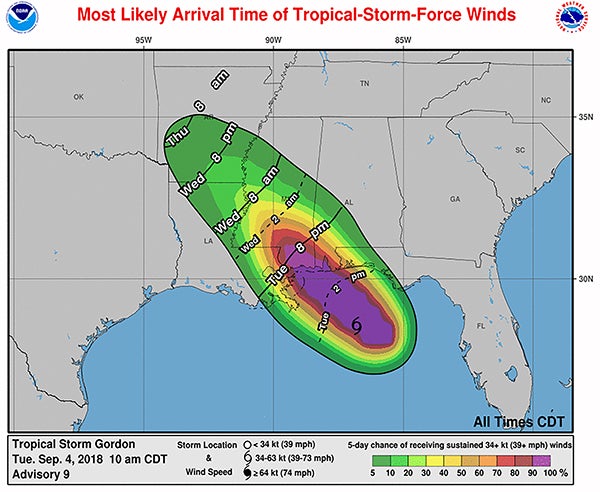
The National Weather Service released its latest update on Tropical Storm Gordon at 10 a.m. Tuesday morning.
Bogalusa City Schools, Washington Parish Schools, Northshore Charter School, Ben’s Ford Christian School, and Annunciation Catholic School will be closed Wednesday, due to the storm forecast.
The NWS update stated:
- Confidence continues to increase that the main impacts from Gordon will be greatest across the Mississippi coastal counties.
- The tropical storm warning has been cancelled for areas generally along and south of a line from Grand Isle to Baton Rouge.
Timing:
Impacts are expected to begin this afternoon and continue through at least Wednesday morning. Onset of tropical storm force winds could begin as early as mid afternoon at the coast, progressing inland through the late afternoon. However, the most likely time of onset is during the early evening hours at the coast, progressing inland through the late evening and overnight.
Wind:
- Potential for winds of 70-80 mph mainly across the Mississippi Coast.
- Potential for winds of 40 to 70 mph across other areas along/east of the I-55 corridor.
- Potential for winds of 25-40 mph elsewhere.
Storm surge:
- 3-5 foot inundation possible along the open coast from Shell beach eastward to the Mississippi/Alabama border.
- 2-4 foot inundation possible along the open coast from the Mississippi River eastward to Shell Beach.
- 1-2 foot inundation along the shores of Lakes Pontchartrain and Maurepas, and along the open coast west of the Mississippi River.
Heavy rain:
- Rainfall totals of 4-8 inches mainly along the Mississippi Coast.
- Rainfall totals of 1 to 4 inches elsewhere.
- Potential for significantly higher local amounts where rain bands move over the same area for a prolonged period.